Mainly following country back roads through farmland and native bush, this trail connects the Tasman towns of Tapawera and Murchison, making this a picturesque alternative to biking along busy SH6.
Passing beside the great wildernesses of Kahurangi and Nelson Lakes national parks, majestic scenery is a feature for much of the route with the bonus of visiting pretty Lake Rotoroa, surrounded by beech forest and mountains.
This trail links with the Tasman's Great Taste Trail at Tapawera, and is not far from The Old Ghost Road, the Golden Downs Trail and Rainbow Trail Heartland Rides.
From Tapawera, the route follows Tadmor Valley Road to Glenhope. The first 24km (Tapawera to Tui) are sealed, while the final 15km (Tui to Glenhope) are along gravel roads. Keep a lookout for the historic railway embankment on your right as you ride up the Tadmor Valley; there are remains of station platforms, bridge abutments and culverts hidden amongst the hop plantations and farmland.
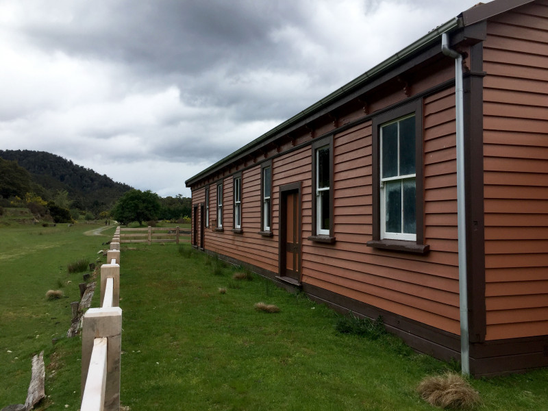
At Glenhope, turn right onto State Highway 6 (SH6). Glenhope's historic railway station will be visible on your right and there is public access via Moon Light Road. This site is being restored by the Department of Conservation and access to the inside can be arranged for groups. It's a good spot to rest and snap a photo.

The restored Glenhope railway station (Josh Aldridge)
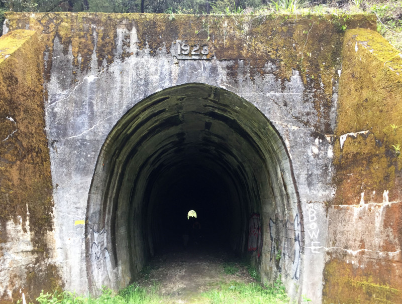
Once back on SH6, follow the highway for 7km to reach Kawatiri Junction where there is a DOC campsite, toilet facilities, and a pretty walk to a historic railway tunnel, built in 1923. Kawatiri is near the mid-point of this Heartland Ride, 46km from Tapawera, and 50km from Murchison.

The historic Kawitiri railway tunnel constructed in 1923 (Josh Aldridge)
From Kawatiri Junction, the route continues along SH6 for a further 6km before turning left onto Gowan Valley Road, and climbing gradually to Lake Rotoroa. Accommodation options at/near the lake include a lodge, B&Bs and DOC campsite with toilet and water supply. Note: the B&B around 1km from the lake also sells coffee!
Lake Rotoroa is 64km from Tapawera, and 32km from Murchison following this Heartland Ride. The lake – 500m off the actual route – is also one of the trail's scenic highlights – lying at the lower end of a trough carved through greywacke mountains by glaciers, it's fringed by beech forest and is supremely pretty on a good day. It's also a good spot to stop for a refreshing dip on a hot summer's day; be prepared for squadrons of sandflies...
From Lake Rotoroa follow the gravel-road Braeburn Track, which climbs for 2.5km (and 210m in elevation) from the lake to the ride's highpoint of 670m. The route then descends from the Braeburn Saddle through dense native bush and four stream crossings; these are concrete fords but be prepared to get wet feet if it's been raining. Turn left onto Tutaki Valley Road, then turn right onto Mangles Valley Road, which returns to SH6. Turn left and follow SH6 for the final 4km into Murchison. From Lake Rotoroa to Murchison the route is 14km gravel and 18km sealed road.
ROAD CONDITIONS
The surface of this route is a combination of sealed country roads (49km), gravel roads (29km) and state highway (17km). This is considered a grade-5 (expert) cycle touring route due to the short sections on the high-traffic State Highway 6 (this may be downgraded to grade 4/advanced once road traffic levels have been evaluated further).
While it mainly follows quiet back country roads, the speed limit is 100 km/h and riders should be prepared to encounter traffic at any time, especially on the state highway sections. The SH6 sections between Glenhope and Gowan Valley Road, and approaching Murchison, can be very busy, especially in peak season; extra care is required.
FITNESS & SKILLS
A moderate level of fitness is required, and riders should be self-sufficient with water and food for 95km (whole route) or 64km (if staying at Lake Rotorua).
TYPE OF BIKE
Touring, gravel/cyclo-cross and mountain bikes are most suitable for the terrain. E-touring bikes, e-gravel bikes and E-MTBs are also suitable, however, riders should ensure that batteries have sufficient capacity and charge to complete the ride. There are no obvious charging points along en route, other than at Tapawera and Murchison accommodation providers, and the lodge/B&Bs at Lake Rotoroa (check with your accommodation prior to setting off).
Riders should ideally have basic mechanical skills and carry a tool kit and spares.
MAPS, NAVIGATION & ELEVATION PROFILE
Generally, this route is well signposted, however, there are numerous turn-offs and junctions. This map will prevent wrong turns, help you time your ride, and identify points of interest along the way.
The elevation profile for the route can be seen here.
WEATHER
It is possible to ride this route all year round. However, it can be subject to heavy rain, snowfall and very cold weather, especially in winter.
The Tasman region also enjoys plenty of hot, sunny days so sunscreen and plenty of water are essential regardless of the time of year.
ACCOMMODATION
A variety of hotel/motel/B&B/holiday park accommodation is available in Tapawera and Murchison. Lodge and B&B accommodation is available at Lake Rotoroa, where there is also a DOC campsite. Kawatiri also has a DOC campsite.
FOOD & WATER
Tapawera has a cafe, takeaway, hotel serving meals and takeaway food, and a Four Square supermarket for food and supplies.
Murchison has cafes, takeaways, a hotel with a restaurant and a Four Square supermarket for food and supplies.
There are water supplies at Tapawera, Kawatiri, Lake Rotoroa and Murchison. The water supplies at the Kawatiri (stream) and Lake Rotoroa (tap) DOC campsites should be boiled or treated.
There are no shops between Tapawera and Murchison so riders should have sufficient food for the whole day.
GETTING HERE
The Intercity bus service between Nelson and Greymouth stops in Wakefield, Kohatu and Murchison.
This Heartland Ride also links up with Tasman’s Great Taste Trail in Tapawera, and is close to the Golden Downs Trail and Rainbow Trail Heartland Rides.
If cyclists are heading south to the Rainbow Trail from Tapawera, it is recommended they join Tasman’s Great Taste Trail to Kohatu, and then cycle to St Arnaud on the Golden Downs Trail via Valley Road. From Tophouse, if you’re planning to ride the Rainbow Trail and don’t need to stop for supplies in St Arnaud, turn left up the gravel road to connect with SH63. Turn left onto SH63 and then right onto Rainbow Road just 700m down the road.
Cyclists who want to connect with the Rainbow Trail from Murchison should follow the Tapawera to Murchison Heartland Ride as far as Kawatiri Junction. From there, the Rainbow is reached via SH63, passing through the village of St Arnaud – gateway to Nelson Lakes National Park. From Kawatiri Junction it's 25km to St Arnaud and a further 8.5km along SH63 to the Rainbow Road turnoff.
CELLPHONE COVERAGE
There is good cellphone coverage at Tapawera and Murchison at each end of the ride, but it is patchy for the rest of the route.
TOILETS
There are public toilets in Tapawera, Murchison, and at the Kawatiri and Lake Rotoroa DOC campsites.
VISITOR INFORMATION
There are visitor information centres at Tapawera and Murchison.

